ON THE GROUND Planner
Start with a reviewed route.
Select the destination and waypoints, calculate and review the route, then export the flight plan for the host autopilot.
OUTPUTReviewed flight plan
Explore Nav Planner ↗
The IMU predicts motion throughout the flight. Radar and thermal matches against stored references correct and cross-check the estimate; a position fix is accepted when both agree. The planned waypoint is a destination, while the sensor matches provide evidence of position.
The IMU predicts position, velocity and orientation 1,000 times a second, including between fixes. Barometer and airspeed feed the same fusion core.
Ground heights measured along the track build a terrain profile beneath the aircraft. Imaging radar adds a 2D ground patch.
The radar profile is matched against the stored terrain map to correct accumulated navigation drift.
A thermal terrain picture is matched against the stored reference scene. The estimate is updated when radar and thermal agree.
Predictable processing is the design objective. L1 runs motion prediction, the radar map match and the thermal scene check on fixed-timing logic. L2 manages navigation services and fallback policy. Explore the proposed board architecture →
TrackFusion runs on an FPGA system-on-chip: fixed-timing logic for the sensor pipeline and ARM cores for the estimate update.
| Step | Input | What happens | Runs on |
|---|---|---|---|
| 1 · Time-stamp + clean | All sensors | A hardware clock time-stamps readings; weak readings are dropped | FPGA |
| 2 · Predict motion | IMU | Position, velocity and orientation predicted 1,000 times a second | FPGA |
| 3 · Ground profile | Radar altimeter | Ground heights along the track build the terrain profile | FPGA |
| 4 · Radar map match | Ground profile, imaging radar | Profile matched against the stored terrain map to correct drift | FPGA |
| 5 · Thermal scene check | Thermal camera | Terrain picture checked against the reference scene | FPGA |
| 6 · Update estimate | Radar + thermal agreement | Along-track and cross-track update; course correction to the autopilot over signed serial | ARM |
GNSS is a check only — compared with the output, never used to navigate. Barometer and airspeed feed the same core. The host autopilot retains flight control.
A defined subsystem for resilient navigation — not a replacement for the host aircraft or autopilot. Fitted at build or retrofitted.
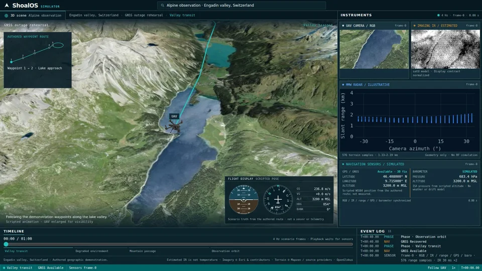
The ShoalOS Simulator flies an authored waypoint route through the Engadin valley, Switzerland. UAV camera, imaging IR, radar and navigation-sensor panels run alongside the 3D scene, with an event log of each phase and GNSS state.
Follow the authored waypoints along the lake valley with GNSS available.
Rehearse the GNSS outage while the route continues.
Cross mountain terrain along the planned route.
GNSS recovered; orbit the observation area.
Scripted animation from an authored route; the UAV is enlarged for visibility. Sensor panels are simulated or illustrative — not flight results. Imagery © Esri & contributors · Terrain © Mapzen / source providers · OpenGlobus.
Ground preparation. Independent navigation. Operator review.
Follow the mission through electronic warfare.
Select the destination and waypoints, calculate and review the route, then export the flight plan for the host autopilot.
Load the terrain map, reference scenes and payload configuration, and expose navigation data to the host aircraft. RECONN.EARTH prepares the thermal reference scenes.
The IMU predicts motion; the radar map match corrects drift and the thermal scene check confirms the fix. GNSS is available but used only as a check.
Electronic warfare denies or spoofs GNSS. Navigation does not depend on it: radar and thermal fixes continue, and a position fix is accepted when both agree.
Navigation confidence and payload health are shared over the secured data link. Systems can retask available resources in response to a failed sensor, drone or mission objective.
Thermal imagery tracks the object while navigation continues. Video and track context return to the operator; the operator and host retain target decisions.
The host autopilot retains flight control. Navigation continues during observation; object tracking is a separate payload function.
SquadSense and Vision SDK ATD/ATR are planned. The flight simulation is a scripted demonstration, not a flight result.